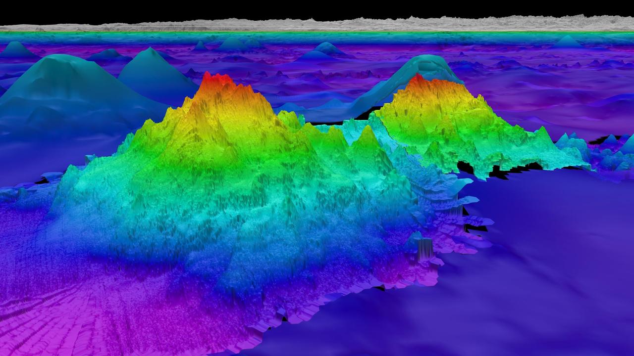
Four gigantic mountains discovered underwater near Chile
Researchers have stumbled across four giant underwater mountains during a mapping expedition from Costa Rica to Chile


READING LEVEL: GREEN
Researchers* have discovered massive underwater mountains off the coast of Chile.
This previously hidden range boasts eight dormant* volcanoes*, towering up to 2.7 kilometres high.
The discovery was made by the Schmidt Ocean Institute team during a mapping* expedition from Costa Rica to Chile aboard the research vessel Falkor (too) in January.
The highest of the seamounts* rises 2681 metres from the sea floor. The smallest seamount found was measured at 1591 metres.
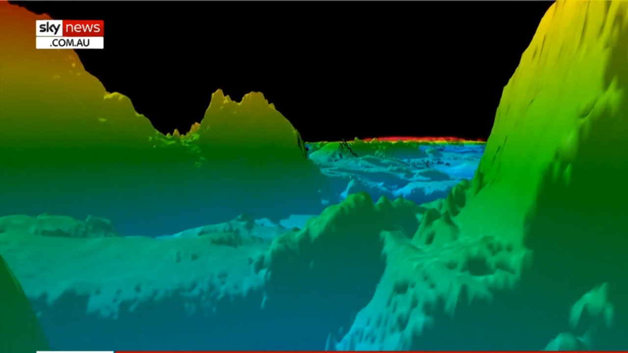
The team uses multibeam mapping* to chart the ocean, with the crew aboard Falkor (too) trained as marine technicians and trained hydrographic* experts, according to a press release* issued by the institute.
Only a fifth of the ocean floor has been mapped, an area of about twice the size of Australia, UNESCO* says, and the vast majority of seamounts have not been explored.

The recently identified sea floor characteristics were absent from existing bathymetric databases*. These underwater mountains and the accompanying trenches* are understudied biodiversity* hotspots, serving as a habitat for myriad deep-sea creatures that cling to the rocky surfaces, such as coral, reefs, and sponges.
"Every time we find these bustling sea floor communities, we make incredible new discoveries and advance our knowledge of life on Earth," Dr Jyotika Virmani, executive director* of Schmidt Ocean Institute said.
The data also helps nations and institutions manage marine resources and can improve safety for the global shipping network*.
An ambitious* effort is under way to map the entire ocean floor by 2030, led by the Japanese not-for-profit* Nippon Foundation-GEBCO Seabed 2030 Project.
The tallest mountain in the world from base to top is Hawaii’s Mauna Kea. The bulk of its 9330 metre height (dry prominence) is beneath the surface of the ocean.
Mount Everest reaches higher into the heavens, with an elevation* above sea level of 8848 metres.
GLOSSARY
- researchers: scientists or experts who study and investigate
- dormant: inactive or not currently erupting (in the context of volcanoes)
- volcanoes: openings in the Earth’s crust through which lava, ash, and gases can erupt
- mapping: creating a detailed representation or chart of an area
- seamounts: underwater mountains or hills
- press release: an official statement or announcement issued to the media
- multibeam mapping: a method of mapping the ocean floor using multiple sonar beams
- hydrographic: related to the measurement and description of the physical features of oceans and other bodies of water
- UNESCO: United Nations Educational, Scientific and Cultural Organization
- bathymetric databases: a record or collection of data related to the depth of the ocean floor
- trenches: deep, narrow depressions on the ocean floor
- biodiversity: the variety of plant and animal life in a particular habitat
- executive director: a senior leader or manager responsible for overseeing an organisation
- shipping network: the system of transportation and delivery of goods by sea
- ambitious: having a strong desire to achieve something challenging
- not-for-profit: an organisation that does not distribute its surplus funds to owners or shareholders
- elevation: the height above a given level, usually sea level
EXTRA READING
Government hands in Reef report
Extreme heat warning for school return
Icelandic volcano erupts and stuns
QUICK QUIZ
- Where did researchers find four giant underwater mountains?
- How many long-dormant volcanoes are part of the massive hidden mountain range?
- What method do the researchers use to map the ocean floor?
- According to UNESCO, what fraction of the ocean floor has been mapped?
- What is the goal of the ambitious effort mentioned in the story, led by the Nippon Foundation-GEBCO Seabed 2030 Project?
LISTEN TO THIS STORY
CLASSROOM ACTIVITIES
Hidden mountain maths
1. What is the difference between the tallest mountain in the world, and the highest mount of this new undiscovered underwater mountain range?
2. What is the difference between Mount Everest and the smallest of the newly discovered underwater mountain range?
3. What do you think the different colours in the imaging map represent?
NB. Answers* at bottom of page
Time: allow 20 minutes to complete this activity
Curriculum Links: English, Mathematics, Geography, Critical and Creative Thinking
2. Extension
What might some of the undiscovered deep sea creatures existing in this non-studied, underwater environment include?
Draw, sketch and name your creature below.
Time: allow 15 minutes to complete this activity
Curriculum Links: Visual Arts, Science
VCOP ACTIVITY
Creative vocabulary
Find a bland sentence from the article to up-level. Can you add more detail and description? Can you replace any ‘said’ words with more specific synonyms?
Have you outdone yourself and used some really great vocabulary throughout your writing? Firstly, well done. Secondly, let’s ensure everyone can understand it by adding a glossary of terms. Pick three of your wow words and create a glossary for each word to explain what it means.
*Answers to Hidden mountain maths:
9330m – 2681 = 6649m
8848 – 1591 = 7257m