NASA animation shows Earth without oceans
Travel back in time thousands of years through this NASA animation to look at Earth without oceans, when vast lands allowed ancient people to roam the world


READING LEVEL: GREEN
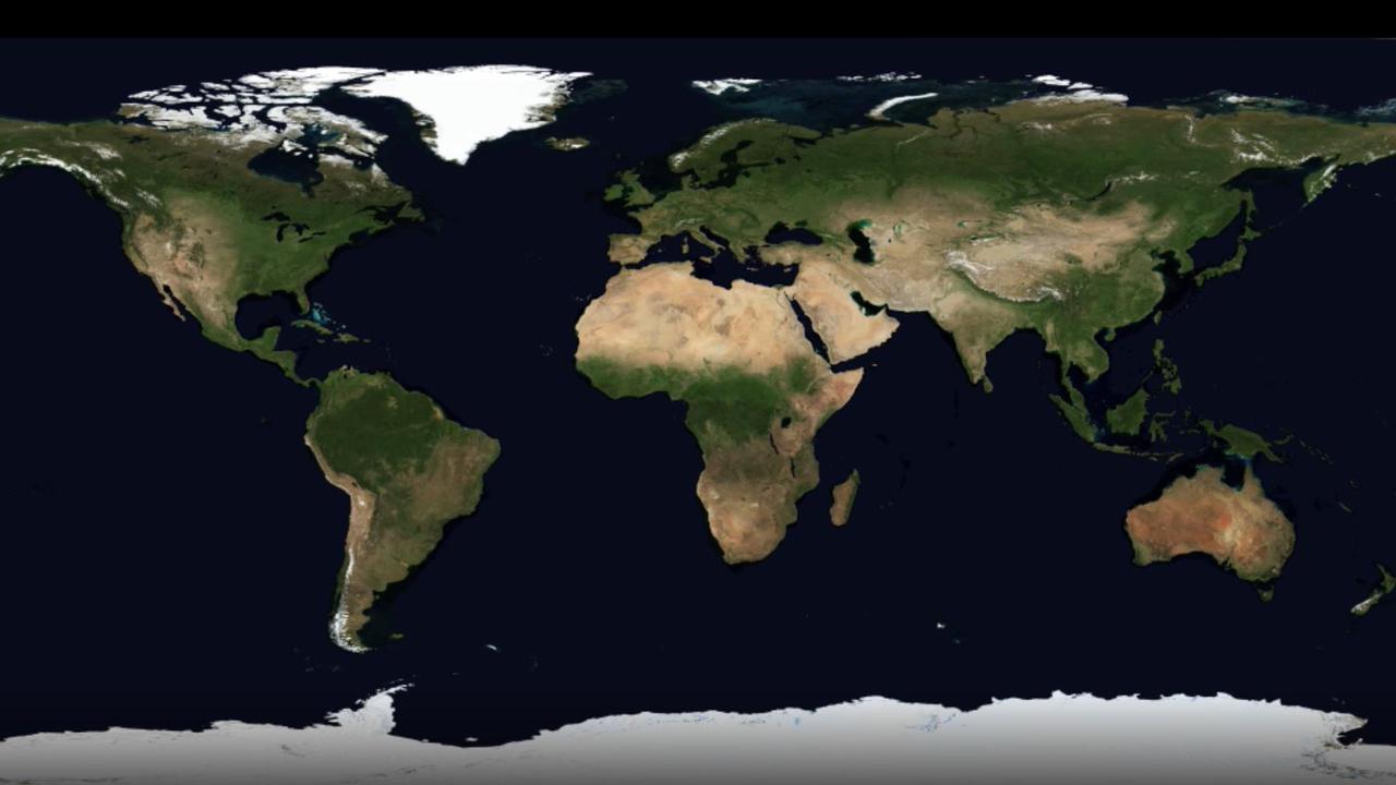
An amazing animation shows what Earth would look like if we drained its oceans.
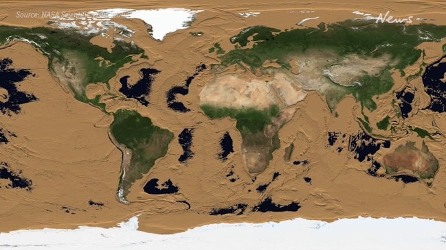
Crafted by NASA, it provides a glimpse* of vast* lands on the outer edges of current land areas that were lost to the sea as recently as 12,000 years ago.
“Three fifths of the Earth’s surface is under the ocean, and the ocean floor is as rich in detail as the land surface with which we are familiar,” NASA said.
“This animation simulates* a drop in sea level that gradually reveals this detail.”
The video begins with a map of Earth showing its continents as we know them today.
With each passing second, the sea level drops by tens of metres to reveal the hidden prehistoric lands of our planet.
First to pop up are the continental shelves – large slabs around a continent’s edge that are submerged* under relatively shallow waters.
This reveals ancient land bridges.
Two of the first to appear as the animation takes us back through time connects mainland Australia with Tasmania to the south and New Guinea to the north.
Another land bridge, known as Doggerland, is between the UK and Europe. It is thought to have been slowly submerged by water between 18,000BC and 5,500BC.
Also known as “Britain’s Atlantis*”, it was an inhabited landscape stretching from Scotland to Denmark and down the English Channel.
Most of the tens of thousands of prehistoric people who lived there are thought to have been killed by a tsunami 8200 years ago.

It’s thought that a continental shelf between Alaska and Russia, known today as the Bering Strait, allowed early humans to cross to the Americas from East Asia during the last Ice Age.
“As the sea level drops, the continental shelves appear immediately,” NASA said of its video, which was first published in 2008.
“They are mostly visible by a depth of 140m, except for the Arctic and Antarctic regions, where the shelves are deeper.”
By 6000m, most of the ocean is drained except for the deep ocean trenches.
These are among the most poorly studied regions on Earth, with many still unexplored by humans.
The deepest ocean trench is the Pacific Ocean’s Mariana Trench at a depth of 11,034m.
This article was first published in The Sun and is republished here with permission.

GLOSSARY
- glimpse: a quick or partial view
- vast: across a very large area
- simulates: imitates the appearance or character of
- submerged: under water
- Atlantis: mythical or fictional city submerged under the ocean
EXTRA READING
Diver breaks record with deepest submarine trip
Hi-tech explorers ‘drain the ocean’
Quest to map world’s oceans by 2030
Neanderthal study rewrites history
QUICK QUIZ
- What proportion or fraction of the Earth is under the ocean now?
- What is a continental shelf?
- What is thought to have happened 8200 years ago?
- Where is the Bering Strait?
- How deep is the Mariana Trench? What ocean is it in?
LISTEN TO THIS STORY
CLASSROOM ACTIVITIES
1. Drained oceans
Divide a page into a chart with four boxes and complete the chart recording your thoughts and reactions as you watch this NASA produced animation on what the Earth would look like if the oceans were drained.
Label the four boxes as:
Observations – what do you notice?
Ocean depths – what happens as the deeper oceans disappear?
What do you notice about the Earth’s topography (study of the shape and features of land surfaces)?
What do you find interesting? What questions do you have?
Time: allow 20 minutes to complete this activity
Curriculum Links: English, Geography, Critical and Creative thinking
2. Extension
What lies beneath these oceans “are among the most poorly studied regions on Earth”. Why do you think this is so? What important historical information could be found by exploring the ocean’s floors?
Time: allow 10 minutes to complete this activity
Curriculum Links: English, Geography, Critical and creative thinking
VCOP ACTIVITY
With a partner see if you can identify all the doing words/verbs in this text. Highlight them in yellow and then make a list of them all down your page. Now see if you and your partner can come up with a synonym for the chosen verb. Make sure it still makes sense in the context it was taken from.
Try to replace some of the original verbs with your synonyms and discuss if any are better and why.
HAVE YOUR SAY: Where would you like to walk to if you could drain the ocean?
No one-word answers. Use full sentences to explain your thinking. No comments will be published until approved by editors.