Google tool gives users Australian air quality updates in real time
Ahead of bushfire season, asthmatics of all ages have a new weapon in their defence against poor air quality as Google Maps provides up-to-date air pollution readings from around Australia

READING LEVEL: ORANGE
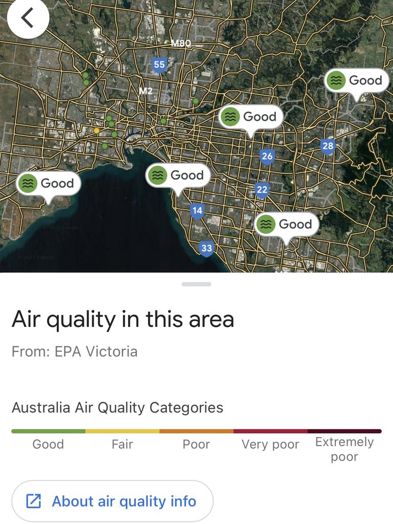
A new online tool will enable users to check air quality across Australia in real time.
The new Google Maps feature enables users to access dedicated air quality information from each state and territory, including warnings if outdoor activities are to be avoided.

Air pollution is measured chiefly in terms of the density* of tiny airborne* particles that are less than 2.5 micrometers in diameter, but readings as high as 26 times greater than that were recorded in Southwestern Sydney and Darwin last year, according to Asthma Australia figures.
A preview of the new tool showed generally good air quality in most Australian cities, but health authorities warn conditions could worsen as bushfire season approaches.

Google Maps product manager Can Comertoglu said Australia was the third country to get the new air quality feature, after the US and India, but there were plans to roll it out globally.
“We have partnerships with the local authorities in every state sending us station data,” Mr Comertoglu said.
“It’s a live feed. Of course it always depends on the update speed of the station and the EPA (Environment Protection Authority), but it’s intended to show you what the situation is right now, or very recently.”

Mr Comertoglu said the air quality feature was being embraced by Google Maps users in the US, with a recent wildfire near Seattle prompting a big spike in residents accessing the information.
Google Maps is supplementing official government air quality readings in the US with results from private citizens using pollution gauges*, but this method could be problematic if a sensor picked up readings from a neighbour’s barbecue, Mr Comertoglu said.

The Australian rollout would feature readings only from government authorities.
Asthma Australia’s Angela Cartwright said “real time, local air quality information supports people to make decisions based on the current conditions”.
But people also needed to know how to respond when the air quality was reduced, Ms Cartwright said.
“This is why we need to see a national air quality public education campaign, which has been recommended by bushfire inquiries and is something we’re working on,” she said.

Air pollution contributes to 3000 premature deaths every year, according to the Lung Foundation Australia. It’s also been linked to increased rates of stroke*, diabetes*, neonatal mortality*, and the onset of neurological* diseases such as Alzheimer’s.
Lung Foundation Australia CEO Mark Brooke said nearly 1000 Australians died prematurely as a consequence of poor air quality from the Black Summer bushfires, and for nonsmokers, air pollution was now the leading cause of lung cancer.

On low air quality days, at-risk people could minimise their risk by staying indoors, ensuring adequate ventilation*, wearing masks if going outside, and keeping both preventive* and rescue medications with them at all times, Mr Brooke said.
GLOSSARY
- density: thickness, concentration, any substance’s mass per unit of volume
- airborne: in the air or carried by air
- gauges: instruments for or means of measuring or testing something
- stroke: medical emergency caused by blood unable to get to the brain due to blockage
- diabetes: chronic disease caused by elevated glucose (blood sugar) levels
- neonatal mortality: the death of a newborn baby in the first 28 days of life
- neurological: relates to branch of medicine dealing with disorders of the brain, spinal cord and nerves
- ventilation: act or process of getting fresh air into a room or building
- preventive: intended to stop something before it happens or becomes a problem
EXTRA READING
Call to turn off engines to protect kids’ health
Bushfires: Sydney’s hazardous air quality
Schools shut as smog smothers Indian capital
QUICK QUIZ
- How many times higher than the base measure of 2.5 micrometers has air pollution been in Southwestern Sydney and Darwin?
- Health authorities warn conditions could worsen as what approaches?
- The Australian tool will only feature readings from which reliable sources?
- Air pollution has been linked to an increased rate of what serious health conditions?
- What can at-risk people do on low air quality days to minimise their risk?
LISTEN TO THIS STORY
CLASSROOM ACTIVITIES
1. Health alert
Medical clinics often display posters to alert and inform waiting patients about health risks. Create a poster like this to alert the public about the dangers of poor air quality and practical steps they can take to minimise their exposure. Use information included in this news story to assist you with the content of your poster.
Time: allow 30 minutes to complete this activity
Curriculum Links: English; Health and Physical Education
2. Extension
Use a device to access the Google Maps app. Use the “Layers” function to check the air quality where (or close to where) you are.
Explore the other available “layers” and write down three useful pieces of information you were able to discover about your current location.
Time: allow 10 minutes to complete this activity
Curriculum Links: English; Geography
VCOP ACTIVITY
Clean air for all
The new Google Maps feature could be a lifesaver for people who have respiratory difficulties. Create an advertisement, in a format that will appeal to our target audience, letting them know about the new feature and the benefits of using it.
Remember to use your VCOP skills to connect with the audience and add voice and style to the piece.

